Introduction to States - Lesson 2
ENDURING UNDERSTANDINGS
Countries are composed of many distinct districts/regions/states
The United States is organized into 50 states.
Content Objectives
Differentiate the different states by recognizing borders
Language Objectives:
Define State
Answer questions relating to far, near, and border
MATERIALS
Promethian Board
Blank Maps of the United States
White Board, Dry Erase Marker, Eraser
Print Outs of continent and ocean names and images
PROCEDURES
OPENER
Do Now – Match the continent/ocean with the name
Distribute different pictures of continental land masses and oceans to half of the students
Distribute different names of the continents and oceans to the other half
Have students stand up in the middle of the room and find the person with the matching name or picture that corresponds to their name or picture.
BODY OF THE LESSON
-Ask students what continent the United States is on. Follow up question of what state do we live in? If students are unable to answer, tell them Pennsylvania is a state and ask them how many states there are. Tell them today we will learn about the 50 states.
-Show powerpoint on states, provinces, districts, and counties. The powerpoint will show the various administrative divisions in the United States (50 states), and the divisions in all of the countries that the students are from (Mexico, Vietnam, China, etc…) I have looked up the various district names of where the hometowns of the students are in order to use them as examples of things similar to states. ( ie: I will display and image of the Mexican states with text saying Mexico City, Federal District because one of the students is from there. This will draw a parallel to the concept of Philadelphia (a city) being located in Pennsylvania (a state).
Distribute white boards and markers after the powerpoint and ask students to write the city they are from and the state/region/district to see if they grasp the concept of states being big areas with many cities in them. Have them erase their answers and write where they are now (Phila, PA).
-Distribute USA Maps with political boundaries and state abbreviations
Display image of the map on the board
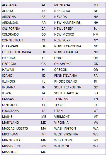
Distribute Paper with all the state names and abbreviations in alphabetical order.
-Introduce the concept of abbreviations
Tell students the 2 letters are a short way of writing the state names
Write examples on the board
Ie: PA = Pennsylvania
NJ = New Jersey
Show examples of other abbreviations, use IOC country codes students may have seen while watching international sporting events
USA – United States of America
CHN – China
PAK – Pakistan
-Ask students to locate states on the map by displaying a state name on the board and verbalizing it. Ask them to put their finger on the location of the state on their map.
-I will ask a question and the students will answer the question by writing the answer on the white board. The students will be divided into three groups (configured differently than the previous days groups) so that they may collaborate while answering the question. Each group will present a single answer on the white board, so a consensus must be achieved before the answer is submitted. All questions will be displayed on the board so students can read the words that I speak in order to familiarize themselves with new vocabulary.
Some questions will include – Name a state that borders Pennsylvania
Name a state that borders the ocean.
What state is north of Oregon?
What state is farther/ more far from Texas, Maine or Missouri?
CLOSURE
What is the smallest state?
Have students write and answer the question on their exit ticket paper. Students must also answer the question of whether they understood the lesson, understood a little, or did not understand. This question will be asked throughout the unit in order to gauge comprehension.
ACCOMMODATIONS
Students who are unsure of the content will be able to work in groups to see how other students are coming to find the correct answers. The students who are having the most trouble will receive individual attention from the CM.
ASSESSMENT/EVALUATION
Individual assessments will be made by checking to see if students are able to locate the correct states on their maps. Assessments will be group based in an effort to have those students who are not as certain about the new material. Those who are confused will be able to learn from their peers who can help them determine the correct answer. Group answers in the white board question activity will be assessed, if students continually get answers incorrect the groups will be shuffled.
Countries are composed of many distinct districts/regions/states
The United States is organized into 50 states.
Content Objectives
Differentiate the different states by recognizing borders
Language Objectives:
Define State
Answer questions relating to far, near, and border
MATERIALS
Promethian Board
Blank Maps of the United States
White Board, Dry Erase Marker, Eraser
Print Outs of continent and ocean names and images
PROCEDURES
OPENER
Do Now – Match the continent/ocean with the name
Distribute different pictures of continental land masses and oceans to half of the students
Distribute different names of the continents and oceans to the other half
Have students stand up in the middle of the room and find the person with the matching name or picture that corresponds to their name or picture.
BODY OF THE LESSON
-Ask students what continent the United States is on. Follow up question of what state do we live in? If students are unable to answer, tell them Pennsylvania is a state and ask them how many states there are. Tell them today we will learn about the 50 states.
-Show powerpoint on states, provinces, districts, and counties. The powerpoint will show the various administrative divisions in the United States (50 states), and the divisions in all of the countries that the students are from (Mexico, Vietnam, China, etc…) I have looked up the various district names of where the hometowns of the students are in order to use them as examples of things similar to states. ( ie: I will display and image of the Mexican states with text saying Mexico City, Federal District because one of the students is from there. This will draw a parallel to the concept of Philadelphia (a city) being located in Pennsylvania (a state).
Distribute white boards and markers after the powerpoint and ask students to write the city they are from and the state/region/district to see if they grasp the concept of states being big areas with many cities in them. Have them erase their answers and write where they are now (Phila, PA).
-Distribute USA Maps with political boundaries and state abbreviations
Display image of the map on the board
Distribute Paper with all the state names and abbreviations in alphabetical order.
-Introduce the concept of abbreviations
Tell students the 2 letters are a short way of writing the state names
Write examples on the board
Ie: PA = Pennsylvania
NJ = New Jersey
Show examples of other abbreviations, use IOC country codes students may have seen while watching international sporting events
USA – United States of America
CHN – China
PAK – Pakistan
-Ask students to locate states on the map by displaying a state name on the board and verbalizing it. Ask them to put their finger on the location of the state on their map.
-I will ask a question and the students will answer the question by writing the answer on the white board. The students will be divided into three groups (configured differently than the previous days groups) so that they may collaborate while answering the question. Each group will present a single answer on the white board, so a consensus must be achieved before the answer is submitted. All questions will be displayed on the board so students can read the words that I speak in order to familiarize themselves with new vocabulary.
Some questions will include – Name a state that borders Pennsylvania
Name a state that borders the ocean.
What state is north of Oregon?
What state is farther/ more far from Texas, Maine or Missouri?
CLOSURE
What is the smallest state?
Have students write and answer the question on their exit ticket paper. Students must also answer the question of whether they understood the lesson, understood a little, or did not understand. This question will be asked throughout the unit in order to gauge comprehension.
ACCOMMODATIONS
Students who are unsure of the content will be able to work in groups to see how other students are coming to find the correct answers. The students who are having the most trouble will receive individual attention from the CM.
ASSESSMENT/EVALUATION
Individual assessments will be made by checking to see if students are able to locate the correct states on their maps. Assessments will be group based in an effort to have those students who are not as certain about the new material. Those who are confused will be able to learn from their peers who can help them determine the correct answer. Group answers in the white board question activity will be assessed, if students continually get answers incorrect the groups will be shuffled.
Do Now Activity
Handouts and Images